Political Geography
Spatial dimensions of political power, borders, states, and geopolitics.
Official Syllabus
NEP-2020 Syllabus
**(4 Credit, Theory: 45hrs, Practical: 30hrs)*
**Unit I* - Political geography: concept, nature, scope and evolution - Concept of state, nation and nation-state - Attributes of state: frontiers, boundaries, buffer zone, population, territory, sovereignty - Geopolitics: concept, and theories (Heartland and Rimland)
**Unit II* - Political geography and systems of government: Federalism, Local self-government administration - Creation of new states - Political geography of resource conflicts: inter-state river water sharing disputes - Conflicts on forest rights and mineral resources - Politics of Displacement: Issues of relief, compensation and rehabilitation (Dams, SEZs)
**Unit III* - Geo-Economic and Political Blocks: UNO, SAARC, ASEAN, NATO, EU, OPEC, BRICS - India as a global power with special reference to G20 - India and its relationship with neighbouring countries: Pakistan, China, Nepal, Bhutan, Bangladesh, Myanmar and Sri Lanka
UGC NET Syllabus
- Boundaries and Frontiers (with special reference to India)
- Heartland and Rimland Theories
- Trends and Developments in Political Geography
- Geography of Federalism, Electoral Reforms in India, Determinants of Electoral Behaviour
- Geopolitics of Climate Change, Geopolitics of World Resources, Geo-politics of India Ocean
- Regional Organisations of Cooperation (SAARC, ASEAN, OPEC, EU)
- Neopolitics of World Natural Resources
NET Political Geography — Detailed Syllabus (Pulakesh Pradhan)
- Definition and Scope of Political Geography
- Geopolitics
- Global Strategic Views (Heartland, Rimland)
- Concept of Nation, State, and Nation-State
- Boundaries and Frontiers
- Politics of World Resources
- Geography of Federalism
Most Important Topics for Exam (NET Notes)
- Heartland Theory
- Rimland Theory
- Geopolitics
- State, Nation, Nation-State
- World Political Geography
- Types of Boundary
Welcome to the Political Geography module of Geography OpenCourseWare.
Part A: Common Topics (NEP-2020 & UGC NET)
These topics are covered in both the NEP-2020 undergraduate syllabus and the UGC NET syllabus.
Concept, Nature, and Scope of Political Geography
| Syllabus | Topic Details |
|---|---|
| NEP-2020 | Unit I — Political geography: concept, nature, scope and evolution |
| UGC NET | Trends and Developments in Political Geography |

Get the Presentation ↗ | Watch the Video ↗
- Definitions: The study of the spatial distribution of political processes and spatial patterns produced by political decisions. (e.g., R. Hartshorne, N.J.G. Pounds).
- Evolution:
- Early phase: Environmental determinism (Ratzel, Semple), Geopolitics (Kjellén, Haushofer).
- Mid-20th Century: Functional approach (Hartshorne), Areal differentiation.
- Modern/Critical phase: Systems analysis, critical geopolitics, electoral geography, political ecology.
- Scope: Ranges from local (electoral redistricting) to national (state formation, boundaries) to global (geopolitics, international organizations).
- Approaches: Morphological (studying structure), Functional (how a state functions), Behavioural, Political Economy approach.
Nature & Scope of Political Geography (NET Notes)
Definitions
- Ratzel: *“Political Geography is the study of the state as an organism attached to the soil”
- Hartshorne: *“Political Geography is concerned with the variation of political phenomena from place to place…”
- Pounds: *“Political Geography is the study of the variation of political phenomena over the earth’s surface”
Scope
- Geography of state boundaries and frontiers, geopolitics, electoral geography, international organisations, war and peace, political regions.
Geopolitics vs. Political Geography
- Geopolitics: Applied/policy-oriented, studies world power, associated with national interest. (Mahan, Mackinder, Spykman, Haushofer)
- Political Geography: Academic/theoretical, spatial variation of political phenomena, objective. (Ratzel, Hartshorne, Pounds)
World Political Map — Shapes of States
- Compact: Poland, Cambodia
- Elongated: Chile, Norway
- Fragmented: Philippines, Indonesia
- Perforated: South Africa (Lesotho)
- Prorupt: Thailand, Namibia
- Enclaves/Exclaves: Enclave (surrounded), Exclave (separated).
State, Nation, and Nation-State
| Syllabus | Topic Details |
|---|---|
| NEP-2020 | Unit I — Concept of state, nation and nation-state; Attributes of state |
| UGC NET | Trends and Developments in Political Geography |
Get the Presentation ↗ | Watch the Video ↗
- State: A politically organized territory with a permanent population, defined territory, and a government with sovereignty (e.g., India, France).
- Nation: A group of people with a shared cultural identity, history, language, or religion, and a strong sense of unity (e.g., the Kurds, the Palestinians).
- Nation-State: When the geographical boundaries of a state coincide exactly with the cultural boundaries of a nation (e.g., Japan, Iceland) — an ideal rarely achieved perfectly.
- Stateless Nation: A nation without a sovereign state of its own (e.g., Kurds, Tibetans).
- Attributes of a State:
- Territory: Land, territorial waters, airspace.
- Population: Citizens and residents.
- Government: Administrative structure.
- Sovereignty: Supreme authority over its territory, free from external control.
State, Nation, and Territoriality (NET Notes)
Definitions & Etymology
- State: Political entity with fixed territory. From Latin ‘status’. “I am the state” — Louis XIV. Four elements: Territory, Population, Government, Sovereignty.
- Nation: Socio-cultural entity. From Latin ‘nasci’ (to be born). Implies common ancestry.
- Hartshorne (1950): Kinship of belonging together, in-groups vs outsiders.
- John Stuart Mill: Mankind united by common sympathies.
- Nation-State: Boundaries of state coincide with cultural boundaries of nation.
- Nationalism: Desire of groups to achieve self-government.
Territoriality
- From Robert Ardrey’s The Territorial Imperative (1966).
- An area of space defended as an exclusive preserve; extended from animal behavior to human political geography.
Boundaries and Frontiers
| Syllabus | Topic Details |
|---|---|
| NEP-2020 | Unit I — Frontiers, boundaries, buffer zone |
| UGC NET | Boundaries and Frontiers (with special reference to India) |
Get the Presentation ↗ | Watch the Video ↗
- Frontiers: Geographic zones or belts that separate states. A Frontier is fundamentally a separation zone between two states or political entities. Margin of settlement, outward-oriented, dynamic, transitional (historical concept, now largely replaced by boundaries).
- Boundaries: Precise linear dividing lines defined by treaties and demarcated on the ground. Inward-oriented.
- Boundary Classification (Genetic):
- Antecedent: Drawn before the area was highly populated (e.g., 49th parallel US-Canada).
- Subsequent: Drawn after settlement, demarcated based on settlements and is modified by human activities and cultural traits (e.g., India-Pakistan borders).
- Superimposed: Forced upon a landscape by outside powers, ignoring cultural realities (e.g., colonial borders in Africa).
- Relict: Ceased to function but its imprint remains on the landscape (e.g., Great Wall of China, Berlin Wall).
- Morphological Classification: Geometric (straight lines), Physiographic (rivers, mountains — e.g., Rio Grande).
- Buffer Zone/State: Weak, independent state located between two major, rival powers (e.g., historical Nepal between British India and China/Tibet).
Boundaries and Frontiers (NET Notes)
Key Distinction
- Frontier: Geographical, Integrating factor, Area.
- Boundary: Political, Separating factor, Line.
Types of Frontiers (Area)
- Natural / Physical: Mountains, rivers, deserts.
- Ethnic / Anthropological: Based on ethnicity/culture.
- Geometrical / Astronomical: Latitudes/longitudes.
- Political: Defined by agreement.
Boundary Classification
- Evolutionary Process: Arbitrary, Evolutionary, Arbitration.
- **By Origin (Jones, 1945 — 4-stage model):*
- Allocation: Political decision.
- Delimitation: Drawn on map.
- Demarcation: Marked on ground.
- Administration: Enforced and managed.
- By Nature: Antecedent (before settlement), Subsequent (after settlement), Superimposed (external power), Relic (historical), Consequent (cultural divide).
Geopolitical Theories: Heartland and Rimland
| Syllabus | Topic Details |
|---|---|
| NEP-2020 | Unit I — Geopolitics: concept, and theories (Heartland and Rimland) |
| UGC NET | Heartland and Rimland Theories |
Get the Presentation ↗ | Watch the Video ↗
- Geopolitics: Term coined by Rudolf Kjellén. The study of the effects of Earth’s geography on politics and international relations.
- Heartland Theory (Halford Mackinder, 1904/1919):
- Divided world into the “World-Island” (Eurasia+Africa) and peripheral islands.
- The “Heartland” (pivot area) is the vast interior of Eurasia, inaccessible to sea power, dominated by land power (railways).
- Dictum: “Who rules East Europe commands the Heartland; Who rules the Heartland commands the World-Island; Who rules the World-Island commands the World.”
- Critique: Ignored the potential of modern technological advancements, especially air power and nuclear weapons, which transcend land barriers.
- Rimland Theory (Nicholas Spykman, 1942):
- Refuted Mackinder. Argued the coastal fringes (Rimland) of Eurasia are more important than the Heartland due to their demographic weight, resources, and access to both sea and land.
- Dictum: “Who controls the Rimland rules Eurasia; who rules Eurasia controls the destinies of the world.”
- Heavily influenced US Cold War “Containment” policy.
- Seapower Theory (A.T. Mahan): Emphasized control of the seas and strategic chokepoints.
Geopolitical Theories — Detailed Concepts (NET Notes)
1. Sea Power Concept — Alfred Thayer Mahan (1890)
- The Influence of Sea Power upon History (1890).
- Control of sea lanes = control of world trade and military power. Strong navies needed.
2. Heartland Theory — Halford J. Mackinder
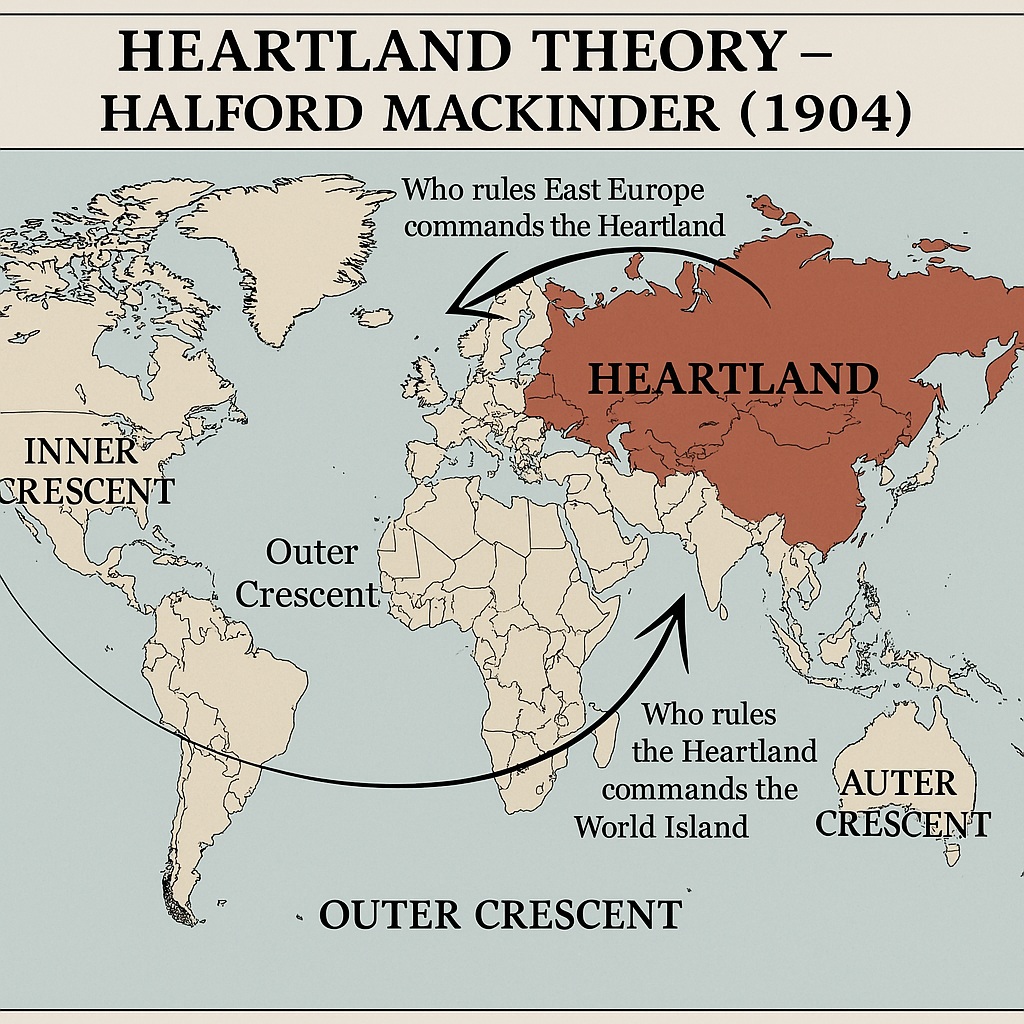
Source: Licchavi Lyceum
- 1904 Model: The Geographical Pivot of History. 4 religious regions = 2/3 world pop coinciding with Five Seas.
- 1919 Model: Democratic Ideals and Reality. Replaced ‘Pivot area’ with ‘Heartland’ due to German rise & Russian communism.
- Dictum: *“Who rules East Europe commands the Heartland; Who rules the Heartland commands the World-Island; Who rules the World-Island commands the World.”
- 1943 Model: The Round World and the Winning of the Peace. Introduced ‘Lenaland’ and ‘Mainland’.
3. Rimland Theory — Nicholas Spykman (1944)
- Geography of the Peace. Opposed land-based power.
- Rimland: Inner crescent of amphibian states (land + sea). Sections: European coastland, Arabian Middle-East, Asiatic monsoon land.
- Dictum: *“Who controls the Rimland rules Eurasia; Who rules Eurasia controls the destinies of the World.”
4. Geopolitik — Karl Haushofer & Rudolf Kjellén
- Rudolf Kjellén: Coined ‘Geopolitik’ (Den Staat als Lebensform). State as a biological organism.
- Karl Haushofer (1924): Edited Zeitschrift für Geopolitik. “A science which deals with the dependence of political events upon the soil.”
5. Later Scholars
- Donald W. Meinig (1958): Heartland and Rimland in Eurasian History.
- Saul B. Cohen (1973): Geography and Politics in a World Divided. Hierarchical model: Geostrategic and Geopolitical regions.
Systems of Government and Federalism
| Syllabus | Topic Details |
|---|---|
| NEP-2020 | Unit II — Federalism, Local self-government administration, Creation of new states |
| UGC NET | Geography of Federalism |
Get the Presentation ↗ | Watch the Video ↗
- Unitary State: Power centralized in a single national government (e.g., France, UK, China). Works best in compact states with homogeneous populations.
- Federal State: Power divided vertically between a central government and sub-national units (states/provinces) (e.g., USA, India, Australia). Accommodates regional diversity and large territories.
- Geography of Indian Federalism: Asymmetrical federalism. Reorganization of states initially on linguistic lines (States Reorganisation Act, 1956), later addressing regional inequalities (creation of Uttarakhand, Jharkhand, Chhattisgarh, Telangana).
- Local Self-Government: Decentralization to grassroots level. In India: 73rd (Panchayati Raj) and 74th (Municipalities) Amendments creating a three-tier system.
- Centripetal vs. Centrifugal Forces: Hartshorne’s concept. Centripetal forces bind a state together (nationalism, institutions, transport network); Centrifugal forces pull it apart (ethnic conflict, regionalism, physical barriers).
Geography of Federalism (NET Notes)
Neumann (1955): *“Federalism is seen as one of the devices to curb the evil use of power by dividing it among a number of competing power units.”
Key Features of Federal State
- Division of powers between central and state/provincial governments
- Written constitution
- Independent judiciary
- Dual citizenship (in some cases)
Types of Political Organisation
- Unitary State: All power at centre (France, UK, Japan).
- Federal State: Powers divided between centre and regions (USA, India, Germany).
- Confederation: Loose union; member states retain sovereignty (EU partially).
Regional Organisations of Cooperation
| Syllabus | Topic Details |
|---|---|
| NEP-2020 | Unit III — Geo-Economic and Political Blocks: UNO, SAARC, ASEAN, NATO, EU, OPEC, BRICS |
| UGC NET | Regional Organisations of Cooperation (SAARC, ASEAN, OPEC, EU) |
Get the Presentation ↗ | Watch the Video ↗
- Supranationalism & Intra-regional Cooperation: Voluntary association of states for mutual benefit. Benefits include increased bargaining power, economic growth, and political stability (it does not aim to limit access to resources).
- Economic Blocs:
- EU (European Union): Deepest integration — free movement of goods, services, capital, people. Common currency (Eurozone).
- ASEAN (Association of Southeast Asian Nations): Economic and security cooperation in SE Asia. It does not act to introduce standard currencies among member states.
- OPEC (Org. of the Petroleum Exporting Countries): Cartel coordinating oil policies and prices.
- Strategic/Political Blocs:
- NATO (North Atlantic Treaty Organization): Collective defense alliance.
- UNO (United Nations): Global governance, peacekeeping, international law.
- Regional/Emerging Blocs:
- SAARC (South Asian Association for Regional Cooperation): Hindered by India-Pakistan tensions. The headquarters of SAARC is situated at Kathmandu.
- BRICS (Brazil, Russia, India, China, South Africa): Emerging economies challenging Western-dominated financial architecture.
India and its Neighbouring Countries
| Syllabus | Topic Details |
|---|---|
| NEP-2020 | Unit III — India and its relationship with neighbouring countries |
| UGC NET | Boundaries and Frontiers (with special reference to India) |
Get the Presentation ↗ | Watch the Video ↗
- International Boundaries: Indian states sharing international boundaries with exactly three countries include Sikkim, West Bengal, and Arunachal Pradesh.
- India-Pakistan: Radcliffe Line, LOC (Line of Control), Siachen Glacier. The boundary is partially marked by rivers, notably the Ravi River. Issues: Kashmir dispute, cross-border terrorism, Indus Water Treaty.
- India-China: McMahon Line, LAC (Line of Actual Control). Issues: Border disputes in Aksai Chin and Arunachal Pradesh, Tibet issue, String of Pearls strategy.
- India-Bangladesh: Longest land border, Radcliffe Line. Resolved issues: Land Boundary Agreement (enclaves), maritime boundary. Ongoing: Teesta river water sharing, illegal migration.
- India-Nepal: Open border (1950 Treaty), Kalapani dispute.
- India-Myanmar: Free Movement Regime, insurgency in Northeast India.
- India-Sri Lanka: Palk Strait, Katchatheevu island, Tamil ethnic issue, Chinese influence in ports (Hambantota).
- Geopolitics of the Indian Ocean: India’s “Necklace of Diamonds” vs. China’s “String of Pearls”. Importance of SLOCs (Sea Lines of Communication).
Part B: NEP-2020 Specific Topics
These topics are part of the NEP-2020 undergraduate programme only.
Political Geography of Resource Conflicts
| Syllabus | Topic Details |
|---|---|
| NEP-2020 | Unit II — Inter-state river water sharing disputes, forest rights, Politics of Displacement |
Get the Presentation ↗ | Watch the Video ↗
- Inter-State River Water Disputes: Triggered by increasing demand, climate change, and regional politics.
- Cauvery: Karnataka, Tamil Nadu, Kerala, Puducherry.
- Krishna: Maharashtra, Karnataka, Telangana, Andhra Pradesh.
- Mahanadi: Chhattisgarh, Odisha.
- Mechanisms: Inter-State Water Disputes Act (1956), Tribunals.
- Conflicts on Forest and Mineral Resources: State vs. local communities/tribals. Niyamgiri hills (Odisha), coal block allocations. Forest Rights Act (FRA, 2006) implementation.
- Politics of Displacement: Development-induced displacement (Dams, SEZs, mining).
- Issues: Inadequate compensation, loss of livelihood, cultural disruption, poor rehabilitation.
- Examples: Narmada Bachao Andolan (Sardar Sarovar Dam), POSCO/Vedanta in Odisha. Land Acquisition Act (LARR, 2013).
Part C: UGC NET Specific Topics
These topics are part of the UGC NET syllabus only.
Electoral Geography
| Syllabus | Topic Details |
|---|---|
| UGC NET | Electoral Reforms in India, Determinants of Electoral Behaviour |
Get the Presentation ↗ | Watch the Video ↗
- Electoral Geography: Spatial analysis of election results, voting behaviour, and the geographical effects of electoral boundaries.
- Gerrymandering: Manipulating electoral district boundaries to give an unfair political advantage to a particular party (Packing and Cracking techniques).
- Determinants of Electoral Behaviour in India: Geography, caste, religion, class, regionalism, language, local issues vs. national issues, incumbency factor.
- Electoral Reforms in India:
- Introduction of EVMs and VVPATs.
- Lowering voting age (61st Amendment).
- NOTA (None of the Above) option.
- Delimitation commissions (freezing of seats to 1971 census populations to not penalize states controlling population).
- Model Code of Conduct, expenditure limits, tackling criminalization.
Geopolitics of Climate Change and Resources
| Syllabus | Topic Details |
|---|---|
| UGC NET | Geopolitics of Climate Change, Geopolitics of World Resources, Neopolitics of World Natural Resources |
Get the Presentation ↗ | Watch the Video ↗
- Geopolitics of Climate Change: Differential impacts and responsibilities. Developed vs. Developing nations (CBDR - Common But Differentiated Responsibilities). Arctic geopolitics (melting ice opening sea routes and resource access). Climate refugees.
- Geopolitics of World Resources (Neopolitics): Shift from territorial conquest to securing control over strategic resources (oil, gas, rare earth elements, water).
- “Resource Curse” in Africa and the Middle East.
- China’s Belt and Road Initiative (BRI) and securing critical minerals in Africa/South America.
- Energy security and pipeline geopolitics (e.g., Nord Stream, TAPI).
- Hydropolitics: Conflicts over international river basins (Nile, Mekong, Jordan, Indus).
Quick Reference
Political Geography Quick Reference
Theories and Models
| Theory / Concept | Propounder | Description |
|---|---|---|
| Organic Theory of State | Friedrich Ratzel | State behaves like a living organism; requires Lebensraum (living space) to survive. |
| Heartland Theory | H.J. Mackinder | “Who rules East Europe commands the Heartland; who rules the Heartland commands the World-Island…” |
| Rimland Theory | Nicholas Spykman | “Who controls the Rimland rules Eurasia; who rules Eurasia controls the destinies of the world.” |
| Geostrategic Realms | Saul B. Cohen | Divided the world into Maritime and Continental realms, and Shatterbelts. |
| Unified Field Theory | S.B. Jones | Links political idea to political area (Idea -> Decision -> Movement -> Field -> Area). |
Key Concepts
- State: A politically organized territory with a permanent population, defined territory, and government.
- Nation: A group of people with a shared culture, language, or history.
- Nation-State: A state whose territory corresponds to that occupied by a particular nation (e.g., Japan).
- Frontier: A geographic zone where no state exercises power (historically).
- Boundary: A precise, invisible line marking the extent of a state’s territory.
- Gerrymandering: Redrawing electoral district boundaries to give a political party an advantage.
Notes compiled by Geography Team